The Water Lines of Nazca
|
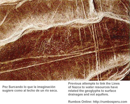
A THEORY ON AN ANCIENT PERUVIAN MYSTERY SUGGESTS THAT THE NAZCA LINES WERE MADE TO MARK THE ORIGINS AND COURSES OF AQUIFERS, THE DESERTS SUBTERRANEAN RIVERS. The province of Nazca on Perú's south coast is a severely arid region, watered only by scattered river valleys. In 1995, while visiting American priests who live there, I suggested I might be able to find subterranean sources of water using the technique of dowsing with metal rods. My offer was met with skepticism, so I suggested they test my system by having me dowse a subterranean water resource which they knew, but I did not.They accepted my offer, and with dowsing accurately measured the width and depth of their chosen water source. They were impressed, and persuaded their Diocese of Jefferson City, Missouri, to invite me back the following July to assist in locating additional water resources for the province. Since then, what began as a search for underground water has evolved into a new interpretation of the hydrology and geology of the region, and of the Nazca Lines themselves. 
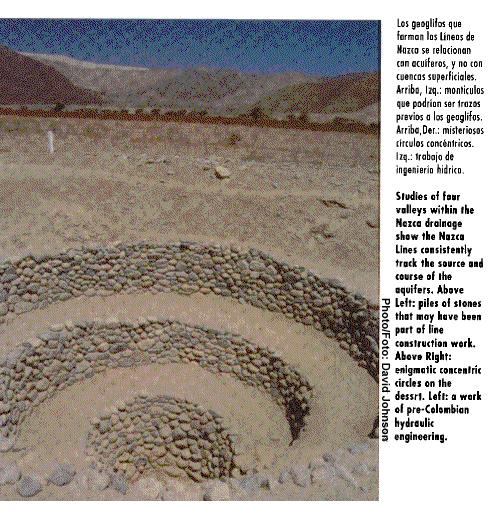
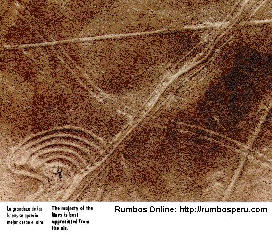
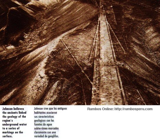
I began my study of the Nazca Valley in 1996, by examining the ancient subterranean aqueducts, known locally as puquios, where the ancient inhabitants dug down to the water table and channeled the water into canals. Historically, the aqueducts have provided a reliable source of water to the valleys, even in years when the rivers are dry and many wells fail. Conventional wisdom held that the puquios were located adjacent to spurs jutting from the foothills of the Andes, and that these, consisting of impermeable strata, redirected meandering subterranean flows of water back into the valleys where the aqueducts captured it. My first discovery at Nazca was that this idea was essentially false. As I observed the location of the aqueducts along the Nazca Valley I had to wonder why most of them paralleled the river rather than crossing it. Considering the scarcity of water in this region one might speculate that they were constructed to capture the highest rates of flow. Thus the aqueducts should cross beneath the river not run parallel to it, as most of them did. I began to wonder if this water came from an entirely different source. The first aqueduct I examined was Achaco, and it turned out to be an ideal place to begin. While dowsing for the aqueducts water source I realized Achaco received its water from an underground channel which lead me northeast to Curve Aqueduct and then on to Aja Aqueduct, approximately four kilometers east of Achaco. I realized that these aqueducts were linked together, part of a single water system. Soon I discovered other linked aqueduct systems within the valley. Previous studies had characterized most of the aqueducts as individual systems. There were no wells between Aja Aqueduct and the river, and dowsing also confirmed that no water flowed into the aqueduct from there. Where did it come from? There were several wells between the aqueduct and a ridge to the north. Dowsing that area I traced a water source which eventually disappeared beneath the ridge. I obtained further proof of the existence of this source by checking the water level of wells along the base of the ridge against the elevation of the river valley. It was twenty meters higher; the water could not possibly come from the river. This was interesting: an aquifer,- a subterranean river,- must flow into the Nazca valley from the north. Water in the Nazca drainage was previously thought to flow exclusively east-west, but my studies revealed that not only the Aja but also other aqueduct systems were receiving water from north- or south-flowing aquifers. To date I have identified nine aquifers in the Nazca, Aja and Tierras Blancas valleys, varying in width from 40 to 50 meters. All of them enter the river valleys at points where there is a fault or some other change in the geological formation, and at each point there stands an ancient aqueduct, constructed by a vanished culture which had learned how to identify subterranean water sources and redirect some of their water to arid regions. For several decades people have theorized that some of the Lines of Nazca are linked to water resources, but they have been unable to prove it. I now saw why: they had related the geoglyphs to surface drainages, and not to aquifers. During my investigation I began to perceive a relationship between many of the Lines of Nazca and the aquifers. Invariably, in those areas where aquifers Flowed and surface sails were not disturbed by alluvial flooding, agriculture or construction, there were geoglyphs. As I identified the aquifers I also realized that various geoglyph types correlated consistently with my calculations. For example, a long triangle identified the source of an aquifer. An isolated zig zag pattern indicated that no water lay below. If I was correct, it meant that the ancients had identified and marked the surface where aquifers emerged from the mountains and crossed the pampa. I then thought: "I can read the geoglyphs, and they will lead me to the aquifers." Reversing my research pattern, I followed the geoglyphs to the aquifers, instead of following the aquifers to determine if they were identified by geoglyphs. Each time geoglyphs clearly identified the aquifers —in some cases, where one would least expect to find them. For example, the geoglyphs crossing the Pan American Highway near Pajonal, just south of Nazca traversed an utterly arid stretch of pampa. How could water exist there? Yet the geoglyphs led to a fault and an intrusive dike at the end of a ridge, just west of a large archeaological site in the Taruga valley. Closer observation indicated a major fault crossing north-south between the Taruga and Nazca Valleys, and intersected by other faults crossing east-west beneath Cerro Blanco. Where this fault enters the Taruga Valley, there are the geoglyphs, three aqueducts and an abundant modern well. Where the fault enters the Nazca Valley stands Cantalloc Aqueduct, numerous geoglyphs known as El Telar, and two abundant wells The El Telar geoglyphs also point directly to molar faults in the mountains. Studies of the four valleys within the Nazca drainage all led to the same conclusion: the Lines of Nazca consistently chart the source and course of aquifers. They are a text without pages imprinted into the landscape, providing the inhabitants of the region, both past and present, with the solution to their water problems. It is thus disturbing that unprotected lines are being destroyed every day by agriculture and construction If this continues, one of the most important manuscripts of the ancient world will be erased forever. Having established the relationship between the faults, aquifers, aqueducts and geoglyphs, I could explore other mysteries of the Nazca drainage. For example, frequently abundant wells were located up valley of dry wells in the same drainage. This could be explained by geological faults which crossed the river, channeling subterranean water away, and these crossings were consistently marked by geoglyphs. |
By David Johnson
Photos: Servicio Aerofotográfico Nacional
Volume III/Issue 11, Page 50
[Top of Page] ![]() http://www.rumbosperu.com
http://www.rumbosperu.com